Bài đăng này xác nhận
quyền sở hữu trang web của tôi và trang web này tuân thủ chính sách
chương trình Google AdSense cũng như Điều khoản và điều kiện:
ca-pub-1550784441625242
Sunday, June 12, 2011
Sunday, May 8, 2011
Scenic Dalat
 | ||
| Thung Lung Tinh Yeu (Valley of Love) is now a park developed by the local government to attract tourists. The valley is approximately 5 km from the center of town. At the floor of the valley is Da Thien lake. To go to the lake there is a small dirt path used for horses. Recently the park attendants have built a series of steps leading to the bottom of the valley. Lake Da Thien is quite small and there are peddles and motorized boats for rent . | ||
Xuan Huong Lake
 | Da Lat is also famous for its many waterfalls and lakes, one of which is Ho Xuan Huong (Xuan Huong lake). This man made lake was a site where many indigenous people of Langbian high land made their homes. In 1984, the lake was emptied for renovation purposes. At the bottom of the lake, scientists found many relics belonging to the hill tribe that once lived in this area. Xuan Huong lake is shaped like the crescent moon. Visitors to Da Lat and the town's people use the lake as a place to meet and talk. The lake is also where many honeymooners come to visit. |
| Xuan Huong lake is the most beautiful lake in Da Lat. It is approximately 5 km2. In 1919 a dam was formed on a branch of Camly river creating a small lake. In 1923, another dam was built further down stream to create yet another lake. During a severe storm in 1932, both dams were destroyed. Between 1934-35, a larger dam was built of boulders (site of Ong Dao bridge today) below the sites of the two previous dam creating one large lake named Ho Lon or Large lake. Ho Lon was later renamed after Ho Xuan Huong, a famous vietnamese poet in the 17th-century. |  |
Da Lat Tourism
 | The first hotel was built in Da Lat around 1907. It was made completely out of wood and was called khach san Ho (Lakeside Hotel - Hotel du Lac). In 1916, work commenced on the Palace hotel. In 1922, the hotel openned to the public. It was the largest and most elegant hotel in this region. |
| Da Lat has many homes built of wood much like the Swiss chalets found in the Alps. It also has many grand villas built by French officials during the early part of the century. Many more villas were built by the South Vietnamese officials in the 60s and 70s. |  |
Da Lat History
 | The first person to explore this region was Mr. Nguyen Thong. Approximately 25 years later, in 1893, Dr. Yersin, a French immunologist discovered Dankia high lands while on an expedition to the Langbian high lands. Dankia is 10 km from the city of Da Lat. This region reminded Dr. Yersin of his homeland, and particularly the similarities between Da Lat's evergreen forests and those in the Swiss Alps. He made the recommendation to the government to form a resort town with health spas for government officials and foreign dignitaries in Dankia. |
| Not long after, Dr. Tardiff, also a French citizen, had an expedition through this region and visited Dankia and Da Lat. He recommended Da Lat to the government due to the favorable water source and locale. At the time, South Vietnam was under French rule, and was known as Cochinchina. The Governor of Cochinchina personally visited Dangkia and Da Lat and decided to take Dr. Tardiff's recommendation. |  |
Travel to Dalat: The Gem of Vietnam's Highlands
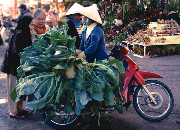 |
| A local woman sells cauliflower in Dalat, Vietnam. |
Vietnam’s Dalat—nicknamed “The City of Love,” “Le Petit Paris,” and “City of Eternal Spring”—has long been popular with Vietnamese and expatriate artists and writers who have taken up residence in villas around town. The area, originally inhabited by the Lat and Ma hill tribes which now live in nearby Chicken Village and Lat Village, increased in popularity during the French colonial era. More than 2,000 beautiful French villas dot the area.
The central part of town is clustered on the northwest side of Xuan Huong Lake where the majority of restaurants, markets, banks, cafes and budget accommodations are found. Footpaths and roads circle the lake, making for easy hikes and bike rides. There are three large cafes built on stilts over the lake. Though better known for their views than food, they do make for convenient rest stops if you decide to make the 3-kilometer hike around the lake.
Dalat is hilly and its sights are spread out, so renting a motorbike or arranging a taxi for a half day or full day is a smart way to see outlying areas. If you select accommodations near Lake Xuan Huong, many sights in town are within walking distance. For outlying areas, Dalat has a unique crew of motorbike guides called Easy Riders. They are all locals, speak fluent English or French, and for $8 per day will guide you around town and the area.
Tuesday, May 3, 2011
Bai Dai Beach Nha Trang

Bai Dai: or Long Beach stretches for 10 km from the southern part of the Lo river along the road from Nha Trang to Cam Ranh Airport. The beach has pristine white sands and shallow turquoise water so its safe for children and non-swimmers. In the summer, travelers can enjoy the tranquil atmosphere and cool breezes whilst lying under the popular trees. However, it can be difficult to find accommodation here. Simple local cafes and restaurants serve a variety of seafood at lower price than in the city of Nha Trang.
How to get there
Take a motorbike or xe om along Nguyen Tat Thanh St. for 10 km from Cam Ranh, then, after passing Dong Bo Mountain, turn off on a smaller to Bai Dai, some 200 meters further on.
Lang Co Beach Hue
 Lang Co Beach is 20 km from Danang and 80 km south of Hue. Lang Co is the most easterly point of Vietnam and is a great place to watch the sunrise.
The beach is a long stretch of fine sand, with a gradual slope and shallow waters. The average sea temperature here is 25 degrees. From here it is easy to reach other great beaches on the Son Tra peninsula. Boats leave from here for Ngoc Island, where there are many aquatic activities on offer.
The Lang Co peninsula is renowned for its myths, history and spectacular landscapes; its where the Chan May and Hoi Cam rivers run into the sea.
Here tourists can enjoy diving, mountain climbing, and expeditions with local fishermen.
This beach in the news
Lang Co is a small fishing village nestled by Hai Van Pass sixty kilometers south of Hue City and forty kilometers north of Da Nang City.
Covering Chuoi (Banana) plain, Ghenh Da (Rocky Bank), and Hai Van Highway, Lang Co Tourism Area is considered one of the four main national tourism destinations in the central region that attract many local and foreign tourists.
In an effort to get rid of the nickname “Forgotten Paradise” given to Lang Co, Thua Thien Hue People’s Committee has paid much effort in organizing the “Legendary Lang Co” Festival in 2005.read more
Photo by fridaycafe
Fortuna Hotel Hanoi
 Everyone passing by Lang Ha street is impressed by the splendid beauty of Fortuna Hotel. And you will also get better impression when staying here. The hotel with 200 rooms will provide you comfortable and convenient place to rest and relax.
In each room, there are modern facilities including telephone, TV and mini bar. Moreover, other services such as dry cleaning and laundry, store and restaurant are always available to satisfy the guests’ demand. The hotel seeks to bring a balance of traditional style and modern comforts to meet the needs of each and every guest.
This combination is one of the factors attracting visitors to the hotel, as the result, the hotel is often full at high season. To make a reservation at the Fortuna Hotel, please enter the dates of your stay and complete our secure online booking form.
How to get there
Fotuna Hotel is the first choice of many guests when coming to Hanoi because of its convenient location. Situated centrally in the embassy and business district of the capital, the Fotuna Hotel is within walking distance to Giang Vo Exhibition Center and 10-15 minutes drive to center of town. Thererfore, you wont miss any big events of business and art at Hanoi when staying in Fotuna Hotel.
Point of view
I have stayed here for 3 weeks while on business and was occupying a premier room where the rooms are large and comfortable. The room comes with a 42-inch LCD TV and a large Jacuzzi bathtub too. The staff were very helpful. If there is a problem, they try to fix it as soon as possible. For instance, they apologized about items I found trivial like a burned out light bulb and the staff replaced it on their own initiative.
Quality control is efficient at this hotel. There are several restaurants featuring several cuisines. The breakfast buffet is international and should satisfy anyone. The local area has many restaurants if you are adventurous.
Staying here on business, I find this hotel very suitable for business meeting because the facilities provided for this purpose, especially large rooms and banquet, are very good. I also recommend this hotel for golf and spa service. It brings me a really relaxing time!
Fortuna Hotel- Ha Noi
Rates: $115-$175
Address: 6B, Lang Ha St, Ba Dinh Dist, Hanoi, Vietnam
Phong Nha / World Heritage
 Geological processes through the ages have bestowed upon Vietnam large areas of limestone. Phong Nha-Ke Bang is representative of such a limestone landscape. Located where the majestic Truong Son range starts, Phong Nha-Ke Bang (Quang Binh province) has within it, numerous inter-linking systems of caves, together with a number of very distinctive underground rivers and streams.
According to data collected in a recent field-study conducted by the British Cave Research Association (BCRA), the total length of the Phong Nha - Ke Bang cave system - as surveyed up to 1997, is 64,386m, comprising 17 separate caverns in two distinct systems, both located in Bo Trach district. The Phong Nha system has 9 caves, with a total surveyed length of 33,758m, while the Vom system has 9, with a total length of 30,627m.
The Phong Nha cave itself (which lends its name to the whole system), in Son Trach village, is probably the most beautiful of all the caves in the region. As studied in 1987, it has a length of 7,729m, and at its maximum point, the ceiling height is 83m. The cave contains many fascinating rock formations, enchanting visitors with evocative names such as Lion, Fairy Caves, Royal Court, Buddha…
The results of their study have enabled BCRA to publish a number of scientifically valuable works about the region. In comparing Phong Nha with other cave systems of the world in general, and of Vietnam in particular, the organization has commented: “Phong Nha, over a 200,000ha. area, has by far the longest underground rivers, the largest caverns and passageways, the widest and prettiest sand banks, and the most astonishing rock formations.”
Nevertheless, Phong Nha - Ke Bang is not famous merely for the marvels of its caves and river, but also for its forests and woods. Research documents from the Institute of Forestry Research have asserted: “The topography of Phong Nha - Ke Bang is a mixture of earth and limestone mountains, with a 90% surface vegetation coverage rate. Of this, 19% by area is occupied by primitive forests, with a huge, and probably unique, biological diversity, containing numerous plants and animals currently listed in the Red Books of protected species of Vietnarn and the world.”
Phong Nha - Ke Bang is also home to the Ruc tribe, only a very small number of which now remains. This is a primitive, cave-dwelling community which, up till only very recently, retained a stone-age way of life and a hunter-gatherer existence.
The Vietnamese Government recently declared Phong Nha-Ke Bang a National Park with 150,000 ha of the area have been placed immediately under the strict management of the local authorities.
After Vietnam joined the international Convention on the Protection of Nature on October 19, 1997, Phong Nha - Ke Bang became one of six regions nominated by the Vietnamese Government to be considered by UNESCO as an official World Natural Heritage Site. Cooperation between the local authorities of Quang Binh province with the Ministry of Culture, the Institute of Forestry Research, and the Ministry of Agriculture and Rural Development have resulted in a comprehensive program to protect and develop this precious natural resource.
Photo by Dust Mason
Hon Yen
 Hon Yen is most famous for Yen Sao which is the name of the nest of Salangane or swifts. The locals harvest the bird nests (considered a delicacy) used in soups. These nests are processed and exported to Taiwan and Hong Kong.
 The birds build their nest high on the walls of the cave on the islands. To access the nests, harvesters must climb on ladders fashioned from bamboo. Because the caves must remain dark lest the birds are scared off, many climbers fall to their death every year trying to harvest the nests.
The bird nest comes in two types, white and red nests. The nest are fashioned by the Salangane that make their homes in caves. The nest are made out of the birds saliva. Usually, a typical bird creates one nest a year during springtime using both parents saliva. Because there is such a demand for their nest (thought to have medicinal qualities), the locals began to remove the nest several times a year causing the birds to have to continue producing the nests.
The red variety of nests are a result of the birds having to create so much saliva for the new nests that they cough up blood along with their saliva causing the nest to take on the red color of their blood. This variety of nest costs their weight in gold or more in the retail market of Hong Kong or Taiwan.
Cau Da
 | Vietnam's first active Oceanographic Institute was built in 1922 at Cau Da (Rock Bridge). The ocean in Nha Trang is quite deep. Here the water is approximately 200 m deep. Beyond 100 km, the depth drops to 2000 m. The Oceanographic Institute was built to study the diverse marine life in this area. |
| The Institute still has samples of sea creatures of this area. Although the institute does not have the modern equipments and facilities to be considered in the same caliber as most western aquariums, it still maintains a fair sample in smaller aquariums. In all, 23 good size aquariums are on display. The institute also has a vast collection of dead samples on display. |  |
Thap Ba (Po Nagar Cham Towers)
| One tower is the shrine to Xiva, one of three most powerful deities in Hinduism. One tower is dedicated to Ganexa, the son of Xiva. This deity has a human body and an elephant head. Po Nagar is the tallest tower, also known as Thap Ba (Tower of the Lady). Po Nagar or Uma is the wife of Xiva the supreme. Po Nagar towers stands 23m in height and was built around 817. |  |
 | Bricks were used in the building of Po Nagar. The four-sided structure is topped by a pyramid with a statue of the four armed Xiva riding Nandin the enchanted ox at the apex. The exterior of the tower is covered by intricate rock carvings of dancers, people rowing boats, grinding rice or hunting with bows and arrows. |
| The interior is airy and cool. An alter made of granite is placed at the base of the statue of Po Nagar. Po Nagar is a goddess with ten arms. She is also the goddess credited for her help with teaching people how to farm. Her statue was originally made out of hard incense wood. The statue was removed by the French in 1946. A new statue with more Vietnamese features is its replacement. The Po Nagar towers complex is an example of Chams architecture and art at its height. |  |
Thap Ba (Po Nagar Cham Towers)
 | The Po Nagar towers once stood at the entrance of Cai river, where the river meets the ocean. The towers stood in isolation on a rock foundation, but over many years the towers and the land it stands on became part of the land mass as the river changed its flows. |
| Today, the tower is north of the river and the rock formation it stood on became known as nui Cu Lao or Mount Cu Lao. The town of Vinh Phuoc at the base of the mountain was once a fishing village, known as Xom Chai and Xom Bong. |  |
 | Po Nagar towers complex was built between the 7th and 12th century. The most beautiful towers were built in the year 813 and 817. Most were destroyed and only four towers are still standing. Each tower is a shrine to a different deity. |
Hon Chong
 | Chong has two meanings in the Vietnamese language. The first is to stack. The second is husband. Hon Chong is located on a stretch of rocky mass of land famous for the thousands of smooth rocks stacking on one another. There are two clusters of such rocks in the area called Hon Chong. The first is further out in the ocean and the second is located near an islet called Sat Thon. The cluster in the ocean is most impressive since there are large boulders stacking on one another seemingly out-of-balance, yet remaining stable. There is a boulder as large as a small hill supporting another boulder as large as a small house at its peak. On the side facing the shore, there is an imprint of a large hand with five fingers clearly outlined. The locals call this rock Hon Chong or the Husband. |
| The cluster with the name Hon Vo or the Wife is not far away. The rocks in Hon Vo cluster are as large as those in Hon Chong, but the they are closer together. A somewhat romantic person explained that this name came about because the rocks here snuggle against one another. |  |
Nha Trang City Beach
| Upon arriving to Nha Trang, most tourists will pass through downtown. Beyond the rows of businesses and homes will be Nha Trang beach. Tran Phu Boulevard is Nha Trang most famous thoroughfare. It runs the length of the beach with several major hotels located within a few steps from the beach. Unlike most major city in Vietnam where the primary mode of transportation is the motorbike, many people of Nha Trang still walk or use the bicycle as their means of getting around. This adds to the tranquillity of the town. There is very little pollution or noise from motor vehicles. |  |
 | On any given day, between 5:00 am to 8:00 am Nha Trang beach is filled with local people taking in the fresh sea breeze, socializing, playing soccer, badminton or practicing Tai chi. Most people in Nha Trang fear being darken by the sun. For this reason, the window between 5-8 am (where sunlight is less intense) is peaked with activities. Another reason is that many go to the ocean for a morning swim, to exercise and to listen to daily news (from the many conspicuously placed loud speakers on electrical poles). In Nha Trang, going to the beach is a family affair. One often see generations of families going to the beach together. However, by 8:00 am the beach is magically emptied of all the hustle and bustle of earlier activities to once again return to silence and serenity. |
On the way to Nha Trang
 | From Saigon going northeast on highway 1 to Nha Trang, the road is extremely bouncy. The trip will take between 9-10 hours. On the way, the two major cities are Phan Rang and Phan Thiet. Both cities are small in size, however, Phan Thiet is very famous for its nuoc mam - fish sauce industry. |
| The next famous site before reaching Nha Trang is Cana beach. This stretch of beautiful white sand is a beautiful beach with a few restaurants; it is a popular rest area for travellers coming from the South. |  |
 | There are many Thanh Long (Green Dragon fruit) orchards along the highway leading to Nha-Trang. This fruit is known to grow only in this region and has become popular only in recent years. |
Nha Trang City

Population: 350, 375 persons
Density of population: 1, 403 person/km2
Nha Trang City is situated in a valley surrounded by mountains on three sides: the North, the West, and the South. The City is bordered by the sea to the East. Cai River of Nha Trang and Cua Be River divide Nha Trang into 3 sections, consisting of 27 communes and wards.
To the North of Cái River are the communes of Vinh Luong, Vinh Phuong, and Vinh Ngoc and the area of Dong De consisting of Vinh Phuoc, Vinh Hai, Vinh Hoa, and Vinh Tho wards.
To the South of Cua Be River are Phuoc Dong commune and Song Lo, an ideal tourist location in the future.
The inner part of Nha Trang City is located between two rivers, consisting of Xuong Huan, Van Thanh, Van Thang, Phuong Sai, Phuong Son, Ngoc Hiep, Phuoc Tien, Phuoc Tan, Phuoc Hoa, Tan Lap, Loc Tho, Phuoc Hai, Phuoc Long, Vinh Truong, and Vinh Nguyen wards and suburban communes to the West: Vinh Hiep, Vinh Thai, Vinh Thạnh, and Vinh Trung.
Nha Trang has 19 islands with more than 2, 500 households and about 15, 000. The largest of these is Tre Island with an area of some 30km2, sheltering the bay from strong winds and waves.
Nha Trang is 1, 280 km from Hanoi, 448 km from Ho Chi Minh City, 630 km from Hue, 105 km from Phan Rang, 260 km from Phan Thiet, and 620 km from Can Tho.
Nha Trang is home to many famous beautiful spots and landscapes and is a major tourist center in the country.
With many universities, academies, research institutes, colleges, vocational schools, and centers for applying scientific-technological advances, Nha Trang has become a center for training and scientific research of Southern Central Vietnam.
A famous specialty of Nha Trang (and also of Khanh Hoa) is the edible swift let nests. All the islands hosting the swift lets are within Nha Trang’s territories.
Typical landscapes and beautiful sites in Nha Trang are Ponagar Tower Temples, Chong Rocks, Do Islet, Yen Islands, Noi Island, Ngoai Island, Mieu Island, Tre Island, Tam Island, Mun Island, Lao Island, Thị Island, Lo River, Tien Beach, Ngoc Thao isle, La-San Hill, Bao Dai Villas, Long Son Pagoda, the White Buddha Statue, Tri Nguyen Aquarium, the Water Palace, Da Hang Pagoda, etc.
Thursday, April 28, 2011
Sơn Trà peninsula
Located at 13km from Đà Nẵng city, the peninsula is 13km long with low-and-high mount-peaks, it looks like open arms to welcome visitors from Eastern sea. Arrivals to Sơn Trà are convenient in both waterways or by roads but assess by waterways is more exciting and surprising.
 |
| Sơn Trà peninsulaPhoto: T.V |
Sơn Trà sea is clearly pearl -like with fine and untapped beaches: Tiên Sa, bãi Bắc, bãi Bụt, bãi Xếp, bãi Nam… an aqua cultural services of Đông Hải Company for export, for fishing sightseeing and study-tours. In the South of the peninsula, there are coral reefs, very good for diving discovery. Famous beaches: Con, Xếp, Rạng… under bushy foliages and visitors could avail themselves of swimming, diving, fishing, squids or shrimps catching, climbing or integrating into locals’ life and enjoy their seafood.
To make the best use of Sơn Trà potentials, the city Đà Nẵng has invested over 1, 000 billions VNĐ in infrastructures and protection of the eco-reserves. The city also invested 500 billions VNĐ besides vital project along the East -West economic corridor to build a tourism belt-ring along Sơn Trà - Điện Ngọc coast, expected to become operational in late 2005 and a tourism bridge to link Liên Chiểu – Thuận Phước road with Sơn Trà at the river -mouth (Hàn). A new tourism complex was started, the first is in Đà Nẵng on the peninsula which will satisfy all visitors’ demands in a 4-star complex with entertainment and water-game services. A water-music park technologically equipped by Japan and Great Britain, a family park, family hotel complex, sports services, diving, surfing, para-sailing.
Sơn Trà discovery is eventful during Đà Nẵng visit. Exciting Sơn Trà will be more attractive and successful in well -managed and well-exploited natural recourses honored by the creator.
CÔNG THÀNH
Đá Dựng mountain
Hà Tiên, the Southernmost province is rich in historic and cultural relics. How could visitors to Hà Tiên forget such beauties and landscapes Thạch Động, Phụ Tử or father -and-son mount, Mạc Cửu tomb, Mũi Nai beach, especially the Đ á Dựng tourism complex.
 |
| Photo: Phạm Lự |
Its legendarily believed that since time mountains met the sea, there were plenty of caves and grottoes and mangroves, an ideal habitat for bird-sanctuaries. Governor of Hà Tiên Mạc Thiên Tích and his learned fellowmen in Chiêu Anh Các (a club of poets) described the scene of white stocks on the mountains to be one of Hà Tiêns ten most beautiful landscapes.
There are 11 caves and grottoes, differently named: Biệt Động, Quân Y, Thạch Sanh, Nam Vang and Hoàng Gia Each name is sourced from a historical event or a man noted for his merits.
Below is cave N04 or Quân Y (or military health service unit) that still retains religious traces of our ancestors. The nature is sparkling in dew-curtain that looks more soleumn and scared at one end of the cave is an ancient pagoda, called Kỳ Sơn Tự.
Thạch Sanh grottoes is on mountain -top, the most beautiful one, stalactites and stalagmites look very much like characters in legendary story Thạch Sanh. There is a fairy -well or Giếng Tiên where fairies normally took a bath. On grotto Trống Ngực, it will make sound like drumbeat when you just lightly flap on your own chest or grotto Rồng where small rocks look like flakes of a dragon.
Visitors to Đá Dựng are happy to discover new thing, apart from mountain climbing, especially to enjoy more legends and folktales told by the local people or written in story-books.
CÔNG THÀNH
Đông Hồ - Hàng Trống new-year paintings
Traditionally, every year when New-year comes, colourful paintings are on sales from cities to countrysides, from lowlands to highlands, that make Tết atmosphere more happy.
As religious beliefs, more people prefer New-year paintings. Sometimes hand-made pictures are in short supply, painters have to print and for generations pictures get produced by printing on wood scripts.
As religious beliefs, more people prefer New-year paintings. Sometimes hand-made pictures are in short supply, painters have to print and for generations pictures get produced by printing on wood scripts.
 |
Đông Hồ artists print pictures on wooden scripts. Colours and carvings are made on wooden boards with chisels while Hàng Trống painters make with knives and chisels.
Đông Hồ artisans print colours first, then the carvings, so many pictures need so many carvings and they use poona-paper to keep long the colours. Ink is made of kinds of grass, plants, fruit, soil that have natural colours that are mixed in with rice-powder. So the paintings can live long. These pictures do not need framing in glass, just sticking on the walls…
Hàng Trống paintings are made in Hàng Trống street (Hà Nội) or in other region of the same style and mostly paintings for worship. Hàng Trống pictures are both painted and printed, the images and style are very flexible and active to meet buyers’ demands. Hàng Trống pictures sometimes are made very large to be hung on high buildings. Hàng Trống pictures depict daily life activities, but almost for worships.
Đông Hồ and Hàng Trống paintings are in fast increase to meet ever -growing sense of beauty of the Hanoians and foreigners during Tết.
HIỀN THANH
Khánh Sơn - homeland
Khánh Sơn, a mountainous district of Khánh Hòa province is rich in natural resources and potentials. Khánh Sơn pass is a must to overcome to arrive at a beautiful spot, Khánh Sơn is home to different ethnic groups: Êđê, Tày, Kinh… Khánh Sơn people have a cultural life of a community and Khánh Sơn is said to be homeland of stone musical sets (dating back to thousand years) have been found here.  Beyond Tô Hạp town is Sơn Bình commune, a river to surprise us by its upstream flow. It’s beyond all explanations why it’s not downstream but upstream – to highland birds are plentiful. There is a forest of 3-leafpine like in Đà Lạt, streams Lớn (big), Nhỏ (small) and Đá Nhảy are good stop -overs to view the scenes.
The most wonderful site in Khánh Sơn is water -fall Tà Gụ, a nice fall, 15m high, in the wild forest. At the foot of the fall, it’s a small lake where we can take a fresh bath.
The peculiar sounds of stone musical set “mà giá” attract numerous tourists whose ambition to see with their naked eyes and to hear the melodious sounds from stone pieces. The elderly mà giá prepare eco -tourism itinerary right in his gardens, fields by side of a stream and close to a shady forest, just to make his stone musical instrument more honorable and more valuable. Tourists can avail themselves of the small but cozy houses, forest or sit on stones by stream sides to enjoy the musical sounds.
To set consists of 4-stone-bars tied to 4 strong columns by rattans and 4 smaller stone used to strike fastens by a long rope to control the striking. The control-point is a pipe made of banana bark. When the pipe is full of water, it will pull the stones down, the water fill out that make the pipe return to starting –point which help make small stones strike on stone bars to have sounds. Low or high melodies depend on whether the stones are tied close to or higher up from the earth.
How interesting it’s to be in an evening in a stilt-house, drinking alcohol (rượu cần), eating baked chicken or chicken-soup, newrice, and listen to melodies tunes from stone sets harmonized with sounds of drums and gongs. It’s quite relaxing.
ÁNH TRINH
Beyond Tô Hạp town is Sơn Bình commune, a river to surprise us by its upstream flow. It’s beyond all explanations why it’s not downstream but upstream – to highland birds are plentiful. There is a forest of 3-leafpine like in Đà Lạt, streams Lớn (big), Nhỏ (small) and Đá Nhảy are good stop -overs to view the scenes. The most wonderful site in Khánh Sơn is water -fall Tà Gụ, a nice fall, 15m high, in the wild forest. At the foot of the fall, it’s a small lake where we can take a fresh bath.
The peculiar sounds of stone musical set “mà giá” attract numerous tourists whose ambition to see with their naked eyes and to hear the melodious sounds from stone pieces. The elderly mà giá prepare eco -tourism itinerary right in his gardens, fields by side of a stream and close to a shady forest, just to make his stone musical instrument more honorable and more valuable. Tourists can avail themselves of the small but cozy houses, forest or sit on stones by stream sides to enjoy the musical sounds.
To set consists of 4-stone-bars tied to 4 strong columns by rattans and 4 smaller stone used to strike fastens by a long rope to control the striking. The control-point is a pipe made of banana bark. When the pipe is full of water, it will pull the stones down, the water fill out that make the pipe return to starting –point which help make small stones strike on stone bars to have sounds. Low or high melodies depend on whether the stones are tied close to or higher up from the earth.
How interesting it’s to be in an evening in a stilt-house, drinking alcohol (rượu cần), eating baked chicken or chicken-soup, newrice, and listen to melodies tunes from stone sets harmonized with sounds of drums and gongs. It’s quite relaxing.
ÁNH TRINH
Ninh Giang earthen crackers
Visit to any hamlet in Ninh Giang (Hải Dương province) is a good opportunity to see traditional contest of earthen crackers organized on Sundays after Tết holidays. And the locals feel very excited to ready themselves for the event, it’s not because of the prize but of their age-long tradition. Earthen crackers are made of special soil carefully processed, they pound the soil to be fine and make square blocks and on the eventful day, young girls bring the soil to the contest-ground.
On the day, the whole villagers attend and the contestants (of all ages) are very skilful, strong and patient. Crackers are varied depending on the weight, but the least weighty must be 10kgs and the most one is 50kgs in different shapes. The finished cracker looks like a boat and the frame is round and large as a bike-tire. The decisive factor in how to drop. Competitors have to unanimously raise the cracker high in the cheers of spectators and precisely, all drop it down how to let it fall on the ground flatly. If it’s too soft, the crackers will get deformed and if it’s too high, it will broak. The winner is decided by the explosion, resounding and echoing. So to get the soil ready plays an important part in the event, just a minor mistake, it will spoil the cracker.
At final round, the champions are privileged to drop the last cracker and the winner will be dressed with a red coat and upheld high by attendants, then everybody tries to tear his shirt, just to take a piece as a lucky sign for the New year.
Don’t hesitate to come and see how the locals get excited for the event and why the game lives long with the tradition.
THANH HƯƠNG
SF - Dinh Cô festival
Dinh Cô is a small temple dedicated to a young virginal girl who got drowned. The temple was built on a hill -top near the beach Long Hải in Bà Rịa - Vũng Tàu province. The festival lasts 3 days (from 10th – 12th of lunar December every year), thousands of visitors come from TP. Hồ Chí Minh city, Lâm Đồng, Bình Thuận and Southwestern.
In the morning of 10th lunar February, the local pay homage to "the girl", each comer has a white lily as symbol of virginity. Many believers try to climb 187 stone-steps to the temple in a view to pray for gook lucks. On 10th and 11th nights, the whole region is brightly lit up with lights and lanterns. Boats from all corners gather here to make the festival more cheerful and exciting.
The ceremony in held on 12th, from the temple, the pilgrims proceed to the berth, get on board, the ships and boats for the prayers. The ceremony is in solemn atmosphere with traditional performance. Dinh Cô festival is a cultural identity of the fishing villages in Bà Rịa - Vũng Tàu.
Việt Nam, a country of 4-season festivals. It's a culture worth being preserved and respected.
SF - Fisher people's festival
 |
| Fishersmen ceremony in Quảng Nam - Đà NẵngPhoto: T.V |
Most exciting is boat-race of the fishing villages and it starts with solemn ceremony competitors show their talents in opening event (4 phases), and each phase with a card to pray for good luck and good weather, good crop.
In fishing village Thuận An (Thừa Thiên – Huế), there's a ceremony of spreading fishing-net that relive the customs of the fishing villages. Firstly, the oldest man is respected to pray for a prosperous year by land Gods, sea Gods… After a round of drumbeat, he drops coins and worship objects on the ground and the children try to take it as gook luck. They are disguised as fish, shrimps… then fishermen bring in a sedan chair with a man on. He spreads the fishing net on the children, the player narrow the round until the children are surrounded.
Children are considered as fish trying to escape, then the fishermen catch the fish. Nice fish are placed nearby the altar, the rest are put "on sales"- everything goes on as well as in real life.
In Quảng Nam - Đà Nẵng, festivals take place normally in lunar mid-March, the locals worship the "Mr Fish" on the Dolphin and also start the fishing season. Fishing boats from all corners gather here. In families, altars are decorated with worship-objects and the ceremony opens on the procession to the open-sea accompanied by performances of folklores and classic opera or tuồng.
Fishing villages in Phú Yên - where almost people earn their living by fishing, the festivals are organized in lunar March when the new fishing season begins to pay their tribute to the forefathers and ancestors to worship "cá ông or the Dolphin", to pray for good and lucky year. The ceremony is held in the village temple with worship offerings, worship speeches, and performances while the festival means games and sports, eating and drinking.
Spring festival - Hung temple festival
 |
| Hung temple festivalPhoto: Trần Tuấn |
The morning of the 10th of lunar March, it's the eventful festival. After 3 rounds bronze drums and gongs, the ceremony opens, then processions from villages proceed to the centre. Processions look very colourful with flags and canopies, musical bands and the pilgrims. At the front-gate, minority girls perform local dance. From door-gate of well-pagoda to lake Đa Vao there are games and sports: dwelling, tug-of-war, arrow-shooting and sedan-chair procession… In the lake, there are boat-races by villagers. Pair of dragon-boats beautifully decorated speed ahead in the cheers of spectators on either banks. In the grounds, there are ball-throw, swinging or singing contests with local songs (xoan, ghẹo).
Hùng temple is a relic -complex that go deep into the hearts of Vietnamese in a view to worship the national founders and the festival is not only for the people at home but for Vietnamese overseas.
Spring festival - Đống Đa festival
 |
| Dragon -dance in Đống Đa festival Photo: Tiến Dũng |
Spring festival 01
Spring in synonym of festivals and it's estimated to be 3,000 in all nationwide. In festivals, there are normally worships, processions, traditional arts, folkloric singing or dances or games.
It's a discovery for foreigners to be in Việt Nam Tết, to find out new sprits, new culture and hospitality of the Vietnamese. Occasionally, VTR presents a few to name in Việt Nam.
It's a discovery for foreigners to be in Việt Nam Tết, to find out new sprits, new culture and hospitality of the Vietnamese. Occasionally, VTR presents a few to name in Việt Nam.
New-year days in the Southwestern part
South Westerners get ready for Tết right from early lunar December. Markets on land or floating meet from 23rd day and the area is said to be a paradise of fruits .
 |
| Eco-tourism in Mêkông DeltaPhoto: Bùi Hỏa Tiễn |
Southern Vietnam is naturally favoured with delicious fruits and the New-year 5-fruit (5 kinds of fruit), tray is very diverse. 5-fruit baskets also displayed in sitting-room to make the house more beautiful. 5-fruit are papaya, orange, milk-fruit, mandarin, durian, pine-apple…
There are candied fruits of different kinds, but most popular is candied coconut-fruit, it’s tasty, easy to make and doesn’t cost much.
From mid-December (lunar month), villagers get busy preparing Tết. They make cakes, sweet porridge, from 29th - 30th of December, cakes are made to worship the forefathers.
Flowers are a must-to-have during Tết holidays and Southern area is rich in flower species and ornamental plants. Bonsai here is nationwide known.
Tết in the Southern part is very specifically tasted, it’s both traditional and modern. It makes the New-year atmosphere more exciting, relaxing and unforgettable.
TÙNG QUÂN
Wednesday, April 27, 2011
Thăng Hen lake in Cao Bằng
Cao Bằng is well-known for its historic spots: Pắc Pó cave, Lê Nin stream or Karmax mountain, but best to name is lake Thăng Hen, 25km from the provincial town.
 |
| Thăng Hen lake in Cao Bằng; Pho to: H.D |
The lake is fresh water among 36 ones, high in the mountain of Trà Lĩnh district. It’s 3.000m long and nearly 1.000m large walled by forests and rocky mounts. The head source of the lake is a large cave where from outflow the unending water that makes the scenery more splendid. The lake has high tide and low tide every day and the lake water is all-year-round clear, in dry season or in flooding season as well.
The legendary lake is a good discovery. It’s rumored that, there is long long ago, a young boy, very smart and handsome who excellently passed his exam and promoted to be a mandarin. He was awarded with 7 days off to pay his tribute to the ancestors in the home village. Before leaving, he got married to a beautiful girl named Bi Óoc. So deep in love and happiness with his newly-wed wife that he forgot the day to return to royal capital. On the 7th night, he remembered his duty and in a hurry to say goodbye to his parents and wife and ran as fast as he could to the capital. Too hungry and too tired to continue his trip, he became exhausted after passing 36 rocky valleys now become 36 lakes with different names and the place he died now is the lake Thăng Hen.
A trip to the lake can be followed by a visit to Bản Giốc waterfall on Sino – Việt Nam border, in Đàm Thủy commune, Trùng Khánh district. The fall Bản Giốc is 53m high and 300m wide, in 3 levels pour down on rocks that make a white curtain of water. Even on hot days, it is cool and fresh here and entices more and more adventurers.
CÔNG THÀNH
Enchanting Ninh Chữ
Ninh Chữ beach, with its 10km length, is situated in Khánh Hải commune, Ninh Hải district, about 6km to the East of Phan Rang - Chàm temple-town, and is considered one of the most beautiful beaches of Việt Nam. At this place, besides swimming and enjoying the fresh seafood, visitors can also visit many places of interest. By cruising in class-bottom boats, visitors will enjoy coral reefs, Thùng beach, Cốc beach, Đá Vách beach and contemplate the wonders of nature on the steep seaside cliffs.
In Ninh Chữ, visitors also have the opportunity to visit the Phước Dinh mobile sand dunes. Twice a year, these dunes at times move into the mainland, at others move out into the sea and are therefore called "mobile sand dunes". Under the hills are small streams curving to lead water into the ocean, and some blue shining lakes.
Night eating is a pleasure for visitors in Ninh Chữ. You can order the delicacies of this region such as clam porridge, or a squid pancake at midnight and still receive a welcoming smile from the vendor. Ninh Chữ, Phan Rang, attracts visitors by its hospitality and friendliness of a tourist site that stays up late.
Night eating is a pleasure for visitors in Ninh Chữ. You can order the delicacies of this region such as clam porridge, or a squid pancake at midnight and still receive a welcoming smile from the vendor. Ninh Chữ, Phan Rang, attracts visitors by its hospitality and friendliness of a tourist site that stays up late.
 |
| Ninh Chữ beach in Ninh ThuậnPhoto: Đỗ Hữu Đức |
Right in Phan Rang town, a Chàm temple is situated on the top of Trầu hill in Đô Vinh district, about 9km to the Northwest of the town named Pôklông Garai temple. It was built at the end of the 18th and the beginning of the 19th centuries. Upon coming here during the Katê festival, the biggest festival of the Chăm people sometimes around October, visitors will be able to observe rituals for offering costumes, sacrifices and bathing ceremonies for the Pôklông Garai statue. At the foot of the Pôklông Garai Chăm temple, a Chăm museum has been erected to display the artifacts of Chăm culture. Along the road from Phan Rang to the sea, a series of big and small hotels have sprung up. A bit further away, visitors can visit Vĩnh Hy bay about 40km to the northeast of Phan Rang. The bay is in the middle of the Vĩnh Hy village (Vĩnh Hải commune, Ninh Hải district) and is a magnificent range with towering mountain tops surrounding a white beach, with mysterious caves, and white bubble waterfalls that carry an air of pristine landscape created by nature.
Ninh Thuận also attracts visitors by its boundless Nam Cương sand dunes, the mystery of the Núi Chúa dried up forest and the distinctive features of Chămpa culture. It is an important connection node constituting the touristic triangle of Đà Lạt - Nha Trang - Ninh Chữ.
THANH TÂM
Ornamental apricots Điền Hòa
It’s a good chance close to Tết or new-year days to visit Điền Hòa commune, Phong Điền district, Thừa Thiên - Huế province and see thousands of ornamental apricot-plants in bloom. Điền Hòa apricots are famous for the flowers (both colour and scent) and the well-experienced apricot-growers.
 |
| Ornamental apricots Điền Hòa - Huế |
| Photo: Như Quỳnh |
Điền Hòa apricots vary in species: hoàng trúc mai, hoàng diệp mai, diệp cúc mai..., but hoàng trúc mai is really a rarity due to its yellow petals and sweet flavours. Mr. Nguyễn Văn Bé said “apricots bloom early or late, that depends on the weather, but hoàng trúc mai (yellow apricot) always bloom in Tết season. Anyway, apricot-plants can be made in different shapes, but mostly in two: long vân and long giáng... In fact, it costs time and effects to have a good ornamental apricot as expected. It needs looking after in years, and there are 4 points to be cared for: the roots, the trunk, the branches, the shape. A good-looking plan must have 4 sides like dragons. In Mr. Được’s opinion, the grower must be very careful in everything to look after, from the time, we place the roots in a vase, then the branches. The vase or pot to grow the apricot must be carefully picked and chosen how to fit the plant both in size and colour. Anyhow “old apricots” need to be grown in old pots. In Điền Hòa park, now there is a hundred-year-old apricot and it blooms every year. The old and big apricots in Huế royal city came from Điền Hòa. In the whole village, now there are 2,000 plants from 10 -15 years old. In all 300 household that have at least 5 - 7 and at most 50-70 apricots. Each costs 3 millions VNĐ or more, same cost up to 40-59 millions VNĐ, especially to 100 millions. Many families become well-off thanks to apricot growing.
During Tết time, we can see apricots everywhere. Vietnamese living overseas, after celebrating at home, buy and transport apricots (by waterways) to France, America and Canada...
THU HẰNG
Wonder - mountain Vệ Linh
Sóc temple complex (in Sóc Sơn, Hà Nội) composes of relics, related to god-hero Thánh Gióng, scattering from mountain-foot to the top, very attractive to visitors on their journey to see the legendary location of ancient Việts in their national construction and defense. From the mountain peak, the whole beautiful region can be viewed.
 |
| Sóc temple festival |
| Photo: Văn Chương |
On 6th of lunar January every year, a festival is organized by villages to commemorate the god Thánh Gióng (in his native land: Phù Đổng village, Gia Lâm district, it’s on 9th of lunar April). There are games and sports activities but most typical is cướp giò hoa. It means the 500 flowers attached to bamboo frame (symbol of the rod used by the god to fight the enemy). The game takes place on the first day, then comes the worship ceremony and it’s the most important for participants. It has been deeply rooted in the spiritual life of the locals and the pilgrims as well.
THU HẰNG
The imperial city of Lê dynasty
Lam Kinh is a historic site in Tho Xuan district, Thanh Hoa province, 200km form Hanoi in the Southwest. It’s a wonderland with rivers and mountains. In the first reign of Le dynasty, Lam Kinh was seen as the second capital of Vietnam. After historical changes and events, palaces, royal temples… now only remain in relics. Untouched by time now stand only the stone-monument Vinh Lang (stele), the tomb of King Le Thai To, the tomb and stele of King Le Hien Tong.
 |
| Lam Kinh citadel |
Just 100m from the front door, there are still relics of the 6m-wide gate and two walls to the sides of Ngoc river. The citadel-foundation is 1.08m thick. 10m from the gate inside, there’s a man-made river, 19m wide. The river is sourced from Tay Ho until Lam Kinh palace. Across the river is an arrow-shaped brige Tien Loan Kieu or Bach Kieu (White brige) with a house on (thuong gia ha kieu). 50m from the brige, there’s an old well, in rectangular (3.5m long, 30m large) with 4 walls built of stone. The well is never dry and the water is very clear.
The tomb of King Le Thai To looks quite modest built on a large area shahed by old trees and plants. The head of the tomb is on the mountain while the side looks to the river. Stud-animals and mandarines were made of stone in small sizes that make the scene solemn but not powerful.
Visitors to Lam King seem to be back to the sacred land where the later Le was born and prosperous and we seem to be hearing the battle sounds of drums in the first days of the resistance. Almost architectural projects were destroyed except the stele-house and the tombs of Kings and Queens remain untouched. Deep in the ground, there are still relics of palaces, temples… and overall, it’s the fighting spirit of Lam Kinh that still lives in the hearts and souls of the Vietnamese.
Lam Kinh historic palace is being upgraded and rebuilt to preserve the traditional culture and architectural of Vietnam in the 15th century, to restore Tay Kinh as a destination for visitors at home and abroad.
KIỀU HƯNG
Forget-me-not Quảng Bình
Located at 491km far from Hanoi in the South and 157km from ancient Hue imperial city in the North, bordered in the North by Ha Tinh province, in the South by Quang Tri, in the West by Laos and in the East by Eastern Sea on 116 km-long seacoast, Quang Binh province has plains, forests, mountains, rivers and islands. Undergone historical changes and natural events, Quang Binh is richly endowed with tourism potentials both in nature and humanism. Right in young city Dong Hoi, a city of tranquility, visitors are able to enjoy beautiful landscapes or strolling on fine beaches, Nhat Le, Quang Phu, Bao Ninh or swimming in clean water. Dong Hoi is also rich in cultural and historic identities, revolutionary traditions such as archaelogical sites Bau Tro, Dong Hoi Citadel, Quang Binh frontier post, Luy Thay....
The eco-tourism complex Phong Nha – Ke Bang is a must-see destination, three are about 300 caves and grottoes, large a small full of mysteries. It’s said to be the world wonder, to be “a Kingdom of Caves”, the paradise for scientists and explorers, tourists. In Phong Nha – Ke Bang virgin forests, there are more than 1000 mountain peaks, rocky, untouched, unexploited and it’s very exciting for adventurers. In the national park Phong Nha – Ke Bang, there is a tropical forest, almost unaffected. It’s covered almost 96,2% and vary in bio-diversity. There are 876 flora species, 140 animal species, 356 bird species, 99 reptile and amplibian species, 259 butterfly, 162 fish, 47 frog species and all these are listed in a red book by IUCN.
Moreover, in Phong Nha – Ke Bang, there are also historic and cultural relics of great values: archaelogical sites of pre – history, Champa culture and ancient Viets, the Anti – French Resistance base of King Ham Nghi in late 19th century (in Ma Rai Mountain) and famous localities: Ho Chi Minh trail, Xuan Son ferry, Nguyen Van Troi ferry, road N0 20, the tangible and intangible cultural values of Chut ethnics along Ho Chi Minh highway 7km from Dong Hoi city, in the West, there’s an eco-cultural tourism complex Vuc Quanh and open museum. Every relics, exhibit here testify to the revolutionary heroism of the Vietnamsese. On a 10 ha – large area, the models and images of Quang Binh people’s work – and – fight life 60 years ago have been reheated with hospital, field clinic, class – room, kindergarten, houses, stores, a – shaped bonch shelter, bomb craters, beaten road.
Bao Ninh village is a red address for visitors to Quang Binh. It’s a fishing village washed in sunshine and fresh air and landscape: sand- hills beaches, rivers, lakes side by side with green forest.
High-end Sun Spa Resort in Bao Ninh is ready at your services and ther are more to see: historic and cultural relics Luy Truong Sa, Sa Chuy post and the homeland of heroic Mother Suot.
PHƯƠNG THẢO
Mẫu Sơn discovery
Mau Son tourism complex in Lang Son province, on 80 mounts and mountains is 1000m high above the sea level. Climate in Mau Son is typically Asian tropical and sub-tropical, cool and bright sunshire in summer, cloudy in winter. In spring, Mau Son seems to be covered by red colour of peach flowers and peach-fruit here are very tasty.
In Mau Son, you can carry out reseach study in virgin forest or climb the peaks Phia Me (1,520m high), Phia Bo (1,511m high). Mau Son forests are rich in flora species: sau sau, nganh nganh, pine-varieties, bamboo-shoots, mushrooms… especially the pure honey. The deeper into the forests, the more precious medicinal herbs we can find ba kich, nhan sam, huyen dang, that diep, ngu gia bi… With which the ethnic minority Dao people process in many traditional medicines, especially herbal bath that help to revitalize when we are tired and exhausted, we can take bath in bath-tub or bring herbs home.
 |
| Mẫu Sơn resort; Photo: K.D |
In Mau Son, there are streams running o flat stones (dozens of meters long) and make waterfalls in windy forests. The stream water and the secret distillery skills help the locals to produce Mau Son alcohol. “Mau Son whisky” is a special product. It’s tasty and easy to make drinkers drunk. Such alcohol can only be made here in Mau Son, no otherwises.
Visitors to Mau Son on spring will be lucky to attend a local wedding ceremony of the Dao minority, to enjoy fried pigs with mac mat leaves and Mau Son alcohol, to take part in singing.
Please, come to Mau Son, just to put away your busy and noisy life in cities, to discover nature, to enjoy local foods and drinks, to find out local life styles and to by local products for souvenirs and presents on the way home.
THANH SƠN
Tân Cương - Tea of Thái Nguyên
Located at about 13km from Thái Nguyên city in the West, Tân Cương is really a destination with natural scenery, sloping hills facing the sunset called “lizard mountain” or “núi Thằn Lằn”. All the streams, headed from the forests, are running along the hill-front to freshen the land of famous tea.
Green environment and clean air seem to activate the community life and to surprise the visitors. Hill after hill, tea garden after each other and the flavour of tea make the whole area scented. Day by day, the locals busy themselves with picking and processing tea-buds, so highly-skilled as the conjurers, they are honoured to be the artisans. Each family has a drying-kiln and a house-owner can act in different roles: a farmer as growing, a worker (in processing) and a dealer (in selling tea). Tea-buds picking is for young girls, that’s why, on every tea-hill, it’s always filled with their laughter and singing. Traditionally, tea was dried in cast-iron pan or bronze pan, it needs patience and good care and only women are patient enough for the job. Nowadays, everything is done by machines, it takes less time. Any way, tea quality much depends on how to adjust the heat, sometimes, it’s up to 1800C for generations, the Tân Cương people can feel the heat with their hands.
Their sensitive and fingers tell them how and when to make the heat high or low. If it’s too hot, tea will become bitter taste. Some skilled people can feel the heat by moving tea leaves. No visitors can come close to the drying pan, although they are carefully instructed.
Tea-buds, after picking, need drying in shades in 3 hours, it’s a precious experience handed down by generations. Visitors to Tân Cương will be guided to the “ancestral land”, to see the old tea-plants in Lam Sơn, under the foot of Guộc mountain. The old tea-trees are so big that a man can only embrace with wide-open arms.
It’s very interesting and joyful to sip the tea in the fresh-air atmosphere while listening to aged people telling the history of their “ancestral land of tea”. Tân Cương tea flavours seem to be the quintessence of natural scents. Don’t forget to buy the local products - Tân Cương tea for your presents and souvenirs when you visit the land.
CÔNG THÀNH
 |
Their sensitive and fingers tell them how and when to make the heat high or low. If it’s too hot, tea will become bitter taste. Some skilled people can feel the heat by moving tea leaves. No visitors can come close to the drying pan, although they are carefully instructed.
Tea-buds, after picking, need drying in shades in 3 hours, it’s a precious experience handed down by generations. Visitors to Tân Cương will be guided to the “ancestral land”, to see the old tea-plants in Lam Sơn, under the foot of Guộc mountain. The old tea-trees are so big that a man can only embrace with wide-open arms.
It’s very interesting and joyful to sip the tea in the fresh-air atmosphere while listening to aged people telling the history of their “ancestral land of tea”. Tân Cương tea flavours seem to be the quintessence of natural scents. Don’t forget to buy the local products - Tân Cương tea for your presents and souvenirs when you visit the land.
CÔNG THÀNH
Mũi Điện - where the sun rise is first seen
On the north - south road, in between cols Cù Mông and Cả, you will see Mũi Điện - where the dawn is first welcome daily in Vietnam mainland.
Mũi Điện (Điện cape) lies on mountain-peak Bà of Đại Lãnh range (part of Trường Sơn range that creates Vũng Rô bay). Mũi Điện is locally named Mũi Nạy due to its look like a tree-branch from the open sea.
 |
| Môn beach |
On maps under Nguyễn dynasty, Đại Lãnh range was carved on Tuyên urn - in Minh Mạng rule (Tuyên is one of 9 dynastic urns still well preserved in the imperial city - Huế ancient capital). In late 19th century, French naval captain Varella, in his inspection tour of South-East Asian sea, discovered the cape and marked on the maritime chart. Due to its importance on water ways in 1980, the French built a light-house on 80m height (above the sea-level) and the sea-farers could see the light on their way, so it was called Mũi Điện (cape of electricity). In 1945, the light-house was out of operation until it was rebuilt in 1995 (on 3rd of July). The house is now one of 45 national ones and it’s one of 8, over one-hundred-year-old light-house in Vietnam. The house is 26m high (inside, there’s a 107 spiral wooden staircase) and it has 26,5 nautical miles in geographical sight with 24 nautical mile light. It’s operated by automatically sun-battery from 6PM to 6AM following day with standard lighting (15 second-cycle) which link the seafarer and the mainland.
Before 2004, it has to take motor-boat to arrive at Mũi Điện. Nowadays, visitors can go by car, there’s a steep-slope road leading to the peak, and a small bay at the food of the mount by side of a sand-hill. Môn beach is 1,5km long with clear water and calm sea, not so deep for children. In the west of the beach, there’s a small spring shared by forests in north Đèo Cả. The spring runs zigzagging on the beach out to the sea. In the evening, visitors will be relaxing by enjoying grilled fish (freshly-caught), listening to tales and stories of the light-house watchmen.
Mũi Điện and the light-house make a wonderful landscape where the dawn is first seen daily, ideal for discovery. The Provincial People’s Committee plans to build it as an attractive destination and festival to welcome sun-rise will be held every year at visitors’ demand.
THU TRANG
Water falls - Tourist potentials of Đắk Nông
In dialect of M’ Nông ethnic minority, Đắk Nông means a gourd of water, a thing inseparable from western highlanders. Đắk Nông is considered as second Đà Lạt in the high plateau, the head sources of rivers and steams which gave rise to a number of beautiful waterfalls: D’ray Sap, Gia Long, Trinh Nữ, Liêng Nung, Đắk Glun, Ba Tầng…
 |
| D'ray Sap water fall |
| Photo: Ngọc Hà |
Trinh Nữ fall (virginity) is about 1km from the district town Cơ Jut in the west. You can walk on stone –steps round the fall viewing natural beauty in the sounds and sights of the fall, you can take a rest or even stay overnight in tent or in stilt-house of the highlanders.
Gia Long fall in about 50m high and 100m large, flowing downstream to river Serepok. There’s a small lake in between the forests, the “Fairy lake” as it’s called, is 80m2 large, clean, clear and beautiful. Gia Long fall is very attractive to visitors.
At about 8km from Gia Nghĩa town in the water fall Liêng Nung, an eco-cultural tourism area. The fall hides itself in the hills and forests. The natural scenery, the noise of falling water and the singing of birds, the 30m-high water flows make the scene more attractive and fascinating.
Apart from rivers and streams, there are large lakes in Đắk Nông such as Easo, West, Trúc, Ea T’linh and Đắc Rông… that have become tourist potentials good for future tourism development.
NGUYÊN HẢI
Tuesday, April 26, 2011
Conquest of Phanxipan
Phanxipan (3.143m high) is the highest mountain in Vietnam and in Indochina as well.
 |
| On the peak of Phanxipan |
Best time for Phanxipan conquest is from September to following March. Anyway, the road to the roof is the finest in late February when wild flowers are in full bloom. What a poetic and romantic scene it’s in the forests and mountains and it’s also good time for nature’s photo-hunters of old conifer-trees green ivory bamboos, clear-water streams, stone-fields and the red sun in floating clouds. Weariness and hardships seem to give way when you put your hands on a metal tower - the bust of President Hồ Chí Minh in a glass case.
For this discovery
Please contact
Vietway Travel
Tel: 04.7724766
Add: P101- K2 - Thành Công, Ba Đình, Hà Nội
Sapa Travel Service
Add: Sapa town
Tel: 020.871674
NGUYỄN VŨ
Phượng Hoàng cave and Mỏ Gà stream
Phượng Hoàng or Phoenix
 |
| Mỏ Gà stream in Thái Nguyên Photo: HD |
When the female laid two eggs, it stayed home and hatched while the made one was away looking for food. One day, he was so busy with natural beauty that he got lost and forgot his wife until he realized it and flied home, only to see his wife turned into stone while waiting for him. So regretful, he lied and looked over the stone, his wife with out eating anything, then he died and the God turned him into stone too, and let them be together. It takes you just one how to reach the top. The cave has 3 floors, the uppermost is Thượng or Dơi cave, then saving or light cave (it’s lighted by sunshine from the East and South East). Giữa cave is about 1000m2 large, there are stalagmites and stalactites and dripping water inside. The underground cave is Dark (sunshine can never reach here).
From the cave-door, we proceed to stream-cave Mỏ Gà. Story has it that long, long ago, it didn’t rain a long time the fields and farmer went into forest cutting wood. A fairy man turned himself into a hen and chickens. The farmer chased to catch the hen and the chickens, but they finally disappeared in a big stone, thinking, they might be these so the farmer moved the stone away, and to his surprise a current of fresh water rushing out. Thanks to this, the fields became green again, crops got bumper and the people’s life changed. Be grateful, the people named their village Mỏ Gà. The stream water is very clean and fresh from inside the mountain. The cave is about 10-20m wide and 2-6m deep (it’s here waist-deep there heel-deep). Nobody known how long the stream is. But when you come inside 300-400m, it looks more attractive, there’s a flat stone like a bed, and it’s called “fairy bed”, there are 5 or 6 small waterfalls.
Mỏ Gà stream and Phượng Hoàng cave become a surprise for tourists.
Stone cathedral Phát Diệm
From Ninh Binh town, it will take you about 30 minutes to arrive at Phát Diệm. Even 3km from afar, the cathedral or the sanctuary could be seen. Its s group of oriental architectural projects in the greenery of old trees and closer at sight, you will see the solemn cross of the sanctuary.
 The Cathedral was built in 24 years (1875-1899). As believed by a professor architect from
 Phát Diệm cathedral complex has 5 buildings and the principal one lies in centre. All churches look imposing and lofty but quite in harmony with natural landscapes and rich in oriental so surrounded by a decorative walls (built of Bát Tràng bricks) on an area of 30.000m2. The walls and the columns outside got damaged by time now.
Phương Đình is the most important of Phát Diệm cathedral. It’s 25m high, 24 m long and 17 wide, all made of stone. The artists – builders were quite talented to put on 3-ton heavy stone. In the middle of Phương Đình (principal hall) there’s a stone bed (made of one stone block), there are outsides and insides stone – panels depicting Vietnam Vietnam
The cathedral “the heart of Virgin Mary”, also called the stone-cathedral was built in 1883. Every thing here is built of marble (the floor, the columns, the beams, the bars, the altars or the towers…typically are the phoenix-panels, the master – pieces in stone scupture. In the end, there are two stone-lions. In 4 corners, there are 4 pictures of seasons (tứ quý) depicting tùng – cúc – trúc – mai (pine - buttercup - ivory-bamboo - apricot), symbols of fine climate and natural beauty. Most impressive might be 4-gods on 4 towers of the belfry, and on top is the cross. At the foot of the belfry are smaller panels depicting the life of the Christen God, and his missonary zeal.
Although faded and damaged by time, the image of lofty Phát Diệm sanctuary still remain. It’s also a good destination for visitors from all corners to Ninh Bình province.
HẢI LÊ
Subscribe to:
Posts (Atom)